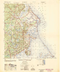
1953 Map of Duxbury
USGS Topo · Published 1954About this map
Captain Hill rises above the coastline, crowned by the Standish Monument and overlooking the storied landscapes of the South Shore during the mid-20th century. This survey documents the historic heart of Duxbury and Marshfield, tracing a maritime and colonial heritage through landmarks like the John Alden House, the Daniel Webster House, and the Burying Ground containing the grave of Myles Standish. The transition from early industry to seasonal recreation is evident, with extensive Cranberry Bogs scattered inland while the Duxbury Yacht Club and shoreline communities like Ocean Bluff and Brant Rock define the waterfront. Along the western edge, the New York New Haven and Hartford Railroad appears as an abandoned line, signaling the shift away from rail-dependent commerce. The map also detailes the protective barrier of Duxbury Beach and the isolated Clarks Island within the complex waters of Duxbury Bay.
Find a feature on this map
101 named features on this map. Tap any name to fly to it.
Don’t see what you’re looking for? This feature index may not catch every label — zoom into the map to look around manually.
Map Details
Editions of this 1953 Duxbury Map
This is the sole edition of this map. No revisions or reprints were ever made.
Other maps of this area

1885 · Abington
USGS Topo · 1:62,500

1885 · Duxbury
USGS Topo · 1:62,500

1885 · Middleboro
USGS Topo · 1:62,500

1886 · Plymouth
USGS Topo · 1:62,500

1888 · Duxbury
USGS Topo · 1:62,500

1888 · Middleboro
USGS Topo · 1:62,500

1888 · Abington
USGS Topo · 1:62,500

1889 · Plymouth
USGS Topo · 1:62,500

1893 · Abington
USGS Topo · 1:62,500

1893 · Duxbury
USGS Topo · 1:62,500