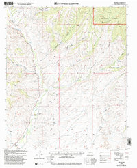
1999 Map of Dwyer
USGS Topo · Published 2002About this map
The Mimbres River valley anchors this late-twentieth-century survey of the high desert terrain in Grant County. Small settlements and ranching outposts like Swartz and Eby Ranch are clustered along the river corridor, which is flanked by an intricate network of drainage systems including Donahue Canyon and Juniper Canyon. A significant portion of the landscape is defined by the Gila National Forest, where the terrain ascends into rugged territory marked by names like Carrizo Canyon and Oak Canyon.
Find a feature on this map
32 named features on this map. Tap any name to fly to it.
Don’t see what you’re looking for? This feature index may not catch every label — zoom into the map to look around manually.
Map Details
Editions of this 1999 Dwyer Map
This is the sole edition of this map. No revisions or reprints were ever made.
Other maps of this area

1935 · Hillsboro
USGS Topo · 1:48,000

1940 · Hillsboro
USGS Topo · 1:62,500

1955 · Las Cruces
USGS Topo · 1:250,000

1956 · Dwyer
USGS Topo · 1:62,500

1956 · San Lorenzo
USGS Topo · 1:62,500

1958 · Las Cruces
USGS Topo · 1:250,000

1962 · Lake Valley
USGS Topo · 1:62,500

1982 · Hatch
USGS Topo · 1:100,000
1985 · Dwyer
USGS Topo · 1:24,000
1985 · P A Mountain
USGS Topo · 1:24,000