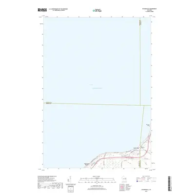
2018 Map of Dyckesville
USGS Topo · Published 2018About this map
The southeastern shoreline of Green Bay and the northern waters of Lake Michigan define this coastal landscape on the edge of Brown and Kewaunee counties. This 2018 survey shows the developed corridor along Sturgeon Bay Rd, where the settlement of Dyckesville serves as a local hub. The map provides clear detail for genealogists tracing family ties to the area, specifically identifying the Saint Louis Catholic Cem near the town center. The shoreline is characterized by small seasonal and residential clusters such as Edgewater Beach and Barretts Point. Inland, a network of local roads including Town Hall Rd and N Sugar Bush RD suggests a transition from the bay-side residential communities to the agricultural character of the surrounding Wisconsin countryside.
Find a feature on this map
29 named features on this map. Tap any name to fly to it.
Don’t see what you’re looking for? This feature index may not catch every label — zoom into the map to look around manually.
Map Details
Editions of this 2018 Dyckesville Map
This is the sole edition of this map. No revisions or reprints were ever made.
Other maps of this area

1952 · Casco
USGS Topo · 1:62,500

1954 · New Franken
USGS Topo · 1:62,500

1954 · Green Bay East
USGS Topo · 1:24,000

1954 · Manitowoc
USGS Topo · 1:250,000

1956 · Oconto
USGS Topo · 1:62,500

1958 · Manitowoc
USGS Topo · 1:250,000

1961 · Little Sturgeon
USGS Topo · 1:62,500
1974 · Pensaukee
USGS Topo · 1:24,000
1974 · Oconto SE
USGS Topo · 1:24,000
1974 · Little Tail Point
USGS Topo · 1:24,000