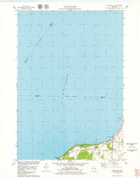
1978 Map of Dyckesville
USGS Topo · Published 1979About this map
Green Bay dominates this late-1970s coastal survey, where the waters meet the indented shoreline of Brown and Kewaunee counties. The small settlement of Dyckesville sits at the intersection of land and water, marking the transition from the maritime expanse to the agricultural interior. Along the coast, Bayshore County Park and Edgewater Beach indicate a landscape utilized for public recreation and seasonal access, supported by infrastructure like the local Boat Ramp. Moving inland, the topography rises toward Dyckes Falls on the Red River, a significant hydrological feature in an area otherwise defined by steady coastal grades. The presence of a Gravel Pit and a Substation near Bader Road suggests a pocket of local industry and utility development serving the nearby residential clusters and rural farmsteads during this era.
Find a feature on this map
17 named features on this map. Tap any name to fly to it.
Don’t see what you’re looking for? This feature index may not catch every label — zoom into the map to look around manually.
Map Details
Editions of this 1978 Dyckesville Map
This is the sole edition of this map. No revisions or reprints were ever made.
Other maps of this area

1952 · Casco
USGS Topo · 1:62,500

1954 · New Franken
USGS Topo · 1:62,500

1954 · Green Bay East
USGS Topo · 1:24,000

1954 · Manitowoc
USGS Topo · 1:250,000

1956 · Oconto
USGS Topo · 1:62,500

1958 · Manitowoc
USGS Topo · 1:250,000

1961 · Little Sturgeon
USGS Topo · 1:62,500
1974 · Pensaukee
USGS Topo · 1:24,000
1974 · Oconto SE
USGS Topo · 1:24,000
1974 · Little Tail Point
USGS Topo · 1:24,000