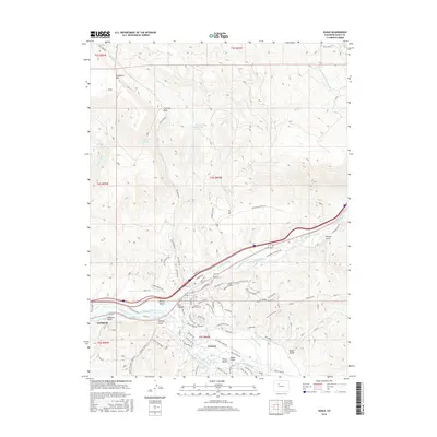
2016 Map of Eagle
USGS Topo · Published 2016About this map
Eagle and Gypsum anchor this high-elevation mountain valley where the Eagle River carves through a landscape of steep gulches and ridges. The map reveals an intricate network of water management, with numerous irrigation features like the Wilkinson Ditch, Hollingsworth-Ditch, and Oleson Ditch supporting the local terrain. Higher elevations are marked by prominent landmarks such as Greenhorn Mtn and Fivemile Rock, while the canyon floor shows the modern expansion of residential streets like Kaibab Rd and Fulford Dr. Local history is preserved in sites such as the Sunset View Cem and the distinctive Spud Cellar near Brush Creek. The geography here transitions sharply from the riparian corridor of the river to the high ridges of The Boneyard and Redneck Ridge, illustrating the balance of mountain ranching and modern residential development.
Find a feature on this map
124 named features on this map. Tap any name to fly to it.
Don’t see what you’re looking for? This feature index may not catch every label — zoom into the map to look around manually.
Map Details
Editions of this 2016 Eagle Map
This is the sole edition of this map. No revisions or reprints were ever made.
Other maps of this area

1957 · Leadville
USGS Topo · 1:250,000

1959 · Leadville
USGS Topo · 1:250,000

1960 · Leadville
USGS Topo · 1:250,000

1962 · Leadville
USGS Topo · 1:250,000

1962 · Gypsum
USGS Topo · 1:24,000
1962 · Suicide Mountain
USGS Topo · 1:24,000

1962 · Fulford
USGS Topo · 1:24,000

1962 · Wolcott
USGS Topo · 1:24,000

1962 · Eagle
USGS Topo · 1:24,000
1962 · The Seven Hermits
USGS Topo · 1:24,000