1962 Map of Fulford
USGS Topo · Published 1964About this map
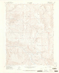
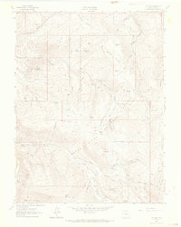
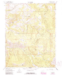
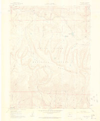
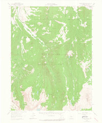
Fulford and its surrounding high-country mining claims are documented in this 1962 field-checked survey, showing the area's transition from active extraction to a landscape of trails and mountain parks. The map details the steep geography of the White River National Forest, where significant peaks like New York Mountain and Adam Mountain overlook a complex network of water sources and gulches. Evidence of earlier industry is preserved through labels for the Lady Belle Mine and the Polar Star Mine, while the social history of the remote settlement is marked by a Cem and the evocative Graveyard Flats. Numerous mountain parks, including Triangle Park, Metheny Park, and Bumpity Park, provide breaks in the vertical terrain. A system of jeep trails and pack trails connects these high-elevation points to water features like East Brush Creek and Nolan Creek, illustrating the logistical challenges of the central Colorado mountains.
Find a feature on this map
61 named features on this map. Tap any name to fly to it.
Don’t see what you’re looking for? This feature index may not catch every label — zoom into the map to look around manually.
Map Details
Editions of this 1962 Fulford Map
4 editions found

Other maps of this area

1909 · Mount Jackson
USGS Topo · 1:125,000

1911 · Mount Jackson
USGS Topo · 1:125,000

1957 · Leadville
USGS Topo · 1:250,000

1959 · Leadville
USGS Topo · 1:250,000

1960 · Leadville
USGS Topo · 1:250,000
1961 · Red Creek
USGS Topo · 1:24,000

1962 · Leadville
USGS Topo · 1:250,000
1962 · Grouse Mountain
USGS Topo · 1:24,000
1962 · Wolcott
USGS Topo · 1:24,000
1962 · Eagle
USGS Topo · 1:24,000