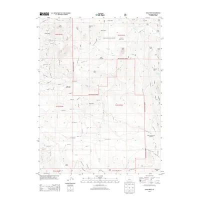
2013 Map of Eagle Rock
USGS Topo · Published 2013About this map
Indian Mountain Ski Area sits in the northwest corner of this high-altitude landscape, overlooking a series of gulches and draws that drain toward Tarryall Cr. The terrain is defined by dramatic peaks like Baker Mountain and the prominent Eagle Rock, surrounded by the protected lands of the Pike National Forest. This 2013 survey illustrates a quiet transition in land use, where traditional agricultural holdings like Paige Ranch and remote drainage features like Schoolmarm Draw and Copenhaver Gulch meet newer recreational and residential footprints.
Find a feature on this map
96 named features on this map. Tap any name to fly to it.
Don’t see what you’re looking for? This feature index may not catch every label — zoom into the map to look around manually.
Map Details
Editions of this 2013 Eagle Rock Map
This is the sole edition of this map. No revisions or reprints were ever made.
Other maps of this area

1937 · Como
USGS Topo · 1:62,500

1953 · Denver
USGS Topo · 1:250,000

1956 · Eagle Rock
USGS Topo · 1:24,000

1956 · Elkhorn
USGS Topo · 1:24,000

1956 · Sulphur Mountain
USGS Topo · 1:24,000

1956 · Farnum Peak
USGS Topo · 1:24,000

1956 · Hartsel
USGS Topo · 1:24,000

1956 · Glentivar
USGS Topo · 1:24,000

1957 · Denver
USGS Topo · 1:250,000
1957 · Milligan Lakes
USGS Topo · 1:24,000