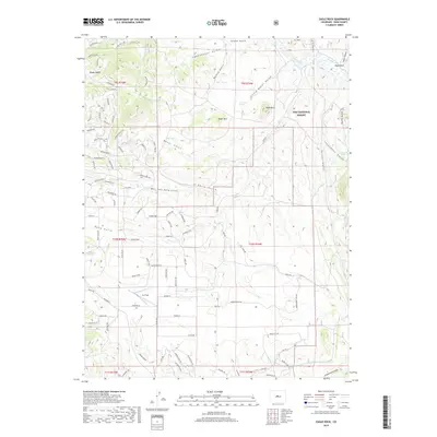
2019 Map of Eagle Rock
USGS Topo · Published 2019About this map
Pike National Forest dominates this high-altitude Park County landscape, where the peaks of Baker Mtn and Eagle Rock overlook a complex network of gulches and seasonal drainages. The topography is defined by the headwaters of Tarryall Cr and numerous springs that sustain the high country, including Harriman Spring, Berkey Spring, and Inbetween Spring. A concentration of mountain residential developments is evident in the western portion, marked by street names like Chippewa Rd and Pehaska Way, while Lux Field sits in the open terrain of Badger Basin. This survey reflects the modern balance between wild forest land and high-elevation land development. Geographic landmarks such as Windy Saddle and Rock Point provide navigation points across the broken terrain of Copenhaver Gulch and Ruby Gulch, tracing the natural paths of water and travel through the Rockies.
Find a feature on this map
107 named features on this map. Tap any name to fly to it.
Don’t see what you’re looking for? This feature index may not catch every label — zoom into the map to look around manually.
Map Details
Editions of this 2019 Eagle Rock Map
This is the sole edition of this map. No revisions or reprints were ever made.
Other maps of this area

1937 · Como
USGS Topo · 1:62,500

1953 · Denver
USGS Topo · 1:250,000

1956 · Eagle Rock
USGS Topo · 1:24,000

1956 · Elkhorn
USGS Topo · 1:24,000

1956 · Sulphur Mountain
USGS Topo · 1:24,000

1956 · Farnum Peak
USGS Topo · 1:24,000

1956 · Hartsel
USGS Topo · 1:24,000

1956 · Glentivar
USGS Topo · 1:24,000

1957 · Denver
USGS Topo · 1:250,000
1957 · Milligan Lakes
USGS Topo · 1:24,000