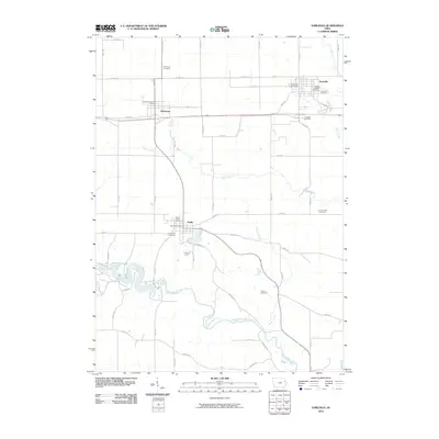
2010 Map of Earlville
USGS Topo · Published 2010About this map
Earlville and the surrounding Delaware County landscape are defined by a grid of agricultural section roads and the winding course of the Maquoketa River. In the northern portion of the map, the town of Earlville serves as a local hub, featuring the Earlville Post Office and nearby Tri-State Raceway. Further south, the settlement of Delhi sits near the banks of the river, which widens into Hartwick Lake to the west. This area contains a high concentration of local burial grounds, including Saint Johns Cemetery, Evergreen Cemetery, and Saint Josephs Cemetery, providing significant points of interest for genealogists tracking early families in the region. The map also captures the path of Old Hwy 20 and the tributary waters of Penn Creek and Plum Creek, illustrating the intersection of historic transit routes and the natural drainage patterns of eastern Iowa.
Find a feature on this map
47 named features on this map. Tap any name to fly to it.
Don’t see what you’re looking for? This feature index may not catch every label — zoom into the map to look around manually.
Map Details
Editions of this 2010 Earlville Map
This is the sole edition of this map. No revisions or reprints were ever made.
Other maps of this area

1900 · Anamosa
USGS Topo · 1:125,000

1902 · Elkader
USGS Topo · 1:125,000

1959 · Dubuque
USGS Topo · 1:250,000

1961 · Dubuque
USGS Topo · 1:250,000

1962 · Dubuque
USGS Topo · 1:250,000

1962 · Petersburg
USGS Topo · 1:24,000

1965 · Thorpe
USGS Topo · 1:24,000
1965 · Dyersville West
USGS Topo · 1:24,000
1965 · Greeley
USGS Topo · 1:24,000

1966 · Hopkinton East
USGS Topo · 1:24,000