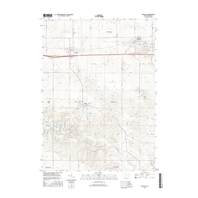
2015 Map of Earlville
USGS Topo · Published 2015About this map
Earlville and the surrounding agricultural lands of Delaware County are defined by a dense network of early 21st-century rural roads and small-town centers. The Maquoketa River winds through the southern portion of the quadrangle, widening into Hartwick Lake and joined by tributaries such as Allison Cr and Penn Cr. This survey illustrates the proximity of the rail-corridor towns of Delaware and Earlville, showing their traditional grid layouts with street names like Main St and Washington St. A notable concentration of community heritage is found in the many burial grounds documented here, including Saint Josephs Cem, Fairview Cem, and Evergreen Cem. In the village of Delhi, the map identifies several civic landmarks such as Saint Johns Cem and local thoroughfares like Market St, reflecting the area's established residential and religious foundations.
Find a feature on this map
53 named features on this map. Tap any name to fly to it.
Don’t see what you’re looking for? This feature index may not catch every label — zoom into the map to look around manually.
Map Details
Editions of this 2015 Earlville Map
This is the sole edition of this map. No revisions or reprints were ever made.
Other maps of this area

1900 · Anamosa
USGS Topo · 1:125,000

1902 · Elkader
USGS Topo · 1:125,000

1959 · Dubuque
USGS Topo · 1:250,000

1961 · Dubuque
USGS Topo · 1:250,000

1962 · Dubuque
USGS Topo · 1:250,000

1962 · Petersburg
USGS Topo · 1:24,000

1965 · Thorpe
USGS Topo · 1:24,000
1965 · Dyersville West
USGS Topo · 1:24,000
1965 · Greeley
USGS Topo · 1:24,000

1966 · Hopkinton East
USGS Topo · 1:24,000