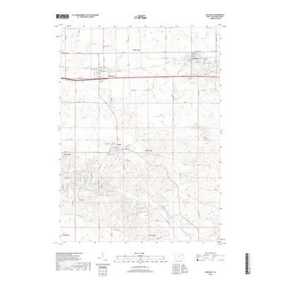
2018 Map of Earlville
USGS Topo · Published 2018About this map
Earlville and the nearby village of Delaware serve as the primary population centers in this section of Delaware County, situated amidst the rolling agricultural landscape of eastern Iowa. The area is defined by its organized grid of rural roads and the winding path of the Maquoketa River in the south. Local heritage is deeply rooted in the land, evidenced by numerous historical burying grounds scattered throughout the quadrangle, including Pine View Cem and the Saint Johns Cem near Delhi. Several tributaries such as Penn Cr, Plum Cr, and Allison Cr drain the terrain, highlighting the importance of these waterways to the local topography and early settlement patterns. Residential streets in Earlville, such as Elizabeth St and Mary St, illustrate the established town layout maintained into the 21st century.
Find a feature on this map
54 named features on this map. Tap any name to fly to it.
Don’t see what you’re looking for? This feature index may not catch every label — zoom into the map to look around manually.
Map Details
Editions of this 2018 Earlville Map
This is the sole edition of this map. No revisions or reprints were ever made.
Other maps of this area

1900 · Anamosa
USGS Topo · 1:125,000

1902 · Elkader
USGS Topo · 1:125,000

1959 · Dubuque
USGS Topo · 1:250,000

1961 · Dubuque
USGS Topo · 1:250,000

1962 · Dubuque
USGS Topo · 1:250,000

1962 · Petersburg
USGS Topo · 1:24,000

1965 · Thorpe
USGS Topo · 1:24,000
1965 · Dyersville West
USGS Topo · 1:24,000
1965 · Greeley
USGS Topo · 1:24,000

1966 · Hopkinton East
USGS Topo · 1:24,000