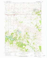
1973 Map of Earlville
USGS Topo · Published 1977About this map
The Maquoketa River carves a winding path through this portion of Delaware County, feeding into the substantial Hartwick Lake reservoir. This 1970s landscape is defined by its agricultural character and the strategic positioning of several small rural hubs including Earlville, Delhi, and Delaware. The region's transport history is visible in the corridor of the Illinois Central Gulf railroad and the Chicago Milwaukee St Paul and Pacific line, which provided vital connections for the local farming economy.
Find a feature on this map
34 named features on this map. Tap any name to fly to it.
Don’t see what you’re looking for? This feature index may not catch every label — zoom into the map to look around manually.
Map Details
Editions of this 1973 Earlville Map
This is the sole edition of this map. No revisions or reprints were ever made.
Other maps of this area

1900 · Anamosa
USGS Topo · 1:125,000

1902 · Elkader
USGS Topo · 1:125,000

1959 · Dubuque
USGS Topo · 1:250,000

1961 · Dubuque
USGS Topo · 1:250,000

1962 · Dubuque
USGS Topo · 1:250,000

1962 · Petersburg
USGS Topo · 1:24,000

1965 · Thorpe
USGS Topo · 1:24,000
1965 · Dyersville West
USGS Topo · 1:24,000
1965 · Greeley
USGS Topo · 1:24,000

1966 · Hopkinton East
USGS Topo · 1:24,000