1977 Map of Earlysville
USGS Topo · Published 1982About this map
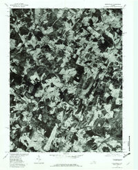
The North Fork Rivanna River system dominates this Albelmarle County landscape, captured in late winter before the spring leaf-out. The resulting orthophotoquad provides an unobstructed view of the land use patterns surrounding Earlysville and Advance Mills. The terrain transitions from the concentrated woodlots of Piney Mountain to the broad, cleared agricultural tracts along Preddy Creek and Swift Run. This 1970s imagery reveals a rural Piedmont environment where large farm parcels remained largely intact, prior to the suburban expansion that would later characterize the region. The drainage network is particularly clear, showing the confluence of the Roach River and Lynch River as they feed into the larger river valley, shaping the historic settlement patterns at Midway and other local crossroads.
Find a feature on this map
10 named features on this map. Tap any name to fly to it.
Don’t see what you’re looking for? This feature index may not catch every label — zoom into the map to look around manually.
Map Details
Editions of this 1977 Earlysville Map
This is the sole edition of this map. No revisions or reprints were ever made.
Other maps of this area

1892 · Gordonsville
USGS Topo · 1:125,000

1892 · Harrisonburg
USGS Topo · 1:125,000

1930 · Madison
USGS Topo · 1:48,000

1931 · University
USGS Topo · 1:62,500

1933 · Madison
USGS Topo · 1:62,500

1935 · Charlottesville
USGS Topo · 1:62,500

1935 · University
USGS Topo · 1:62,500

1937 · Elkton
USGS Topo · 1:62,500

1939 · Charlottesville
USGS Topo · 1:62,500

1949 · Charlottesville
USGS Topo · 1:250,000