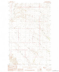
1984 Map of East Butte
USGS Topo · Published 1984About this map
East Butte dominates the northern horizon of this landscape, serving as a primary geological landmark in this part of Blaine County. The terrain is defined by an intricate drainage system, where the East Branch Thirtymile Creek and the various branches of Wayne Creek carve out the topography. The presence of Box Spring in the northwest suggests a critical water source for early ranching and land use in this semi-arid region. To the south, the network of Forgey Creek and its West Fork Forgey Creek illustrates the complex seasonal water flow patterns that shaped local movement and settlement. These family-named watercourses, such as the forks of Wayne Creek, provide essential geographic anchors for genealogists and local historians tracing land patents and the development of high-plains agriculture.
Find a feature on this map
9 named features on this map. Tap any name to fly to it.
Don’t see what you’re looking for? This feature index may not catch every label — zoom into the map to look around manually.
Map Details
Editions of this 1984 East Butte Map
This is the sole edition of this map. No revisions or reprints were ever made.
Other maps of this area

1903 · Wayne Creek
USGS Topo · 1:62,500

1905 · Wayne Creek
USGS Topo · 1:62,500

1905 · Harlem
USGS Topo · 1:62,500

1913 · Cherry Ridge
USGS Topo · 1:125,000

1953 · Havre
USGS Topo · 1:250,000

1957 · Havre
USGS Topo · 1:250,000

1958 · Havre
USGS Topo · 1:250,000
1964 · Grable Coulee
USGS Topo · 1:24,000
1964 · Fort Belknap Siding
USGS Topo · 1:24,000
1964 · Harlem
USGS Topo · 1:24,000