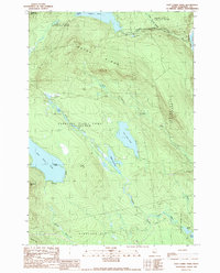
1989 Map of East Carry Pond
USGS Topo · Published 1989About this map
The Appalachian National Scenic Trail winds through the heart of this Somerset County landscape, tracing the high ground above a series of significant glacial water bodies. This 1989 survey reveals the remote character of the Maine woods during the late twentieth century, where the primary human mark on the land is a network of trails and unimproved roads used for forestry and recreation. The geography is dominated by the linear alignment of West Carry Pond, Middle Carry Pond, and East Carry Pond, which serve as a natural corridor through Carrying Place Town. To the east, the Kennebec River forms a major boundary near Caratunk. High points such as Bates Ridge and Roundtop Mtn overlook the drainage systems of Sandy Stream and Jewett Stream, illustrating the complex hydrology that historically defined portage routes in this region.
Find a feature on this map
32 named features on this map. Tap any name to fly to it.
Don’t see what you’re looking for? This feature index may not catch every label — zoom into the map to look around manually.
Map Details
Editions of this 1989 East Carry Pond Map
This is the sole edition of this map. No revisions or reprints were ever made.
Other maps of this area

1903 · Bingham
USGS Topo · 1:62,500

1905 · Bingham
USGS Topo · 1:62,500

1905 · The Forks
USGS Topo · 1:62,500

1907 · The Forks
USGS Topo · 1:62,500

1925 · Pierce Pond
USGS Topo · 1:48,000

1927 · Pierce Pond
USGS Topo · 1:62,500

1928 · Dead River
USGS Topo · 1:62,500

1931 · Dead River
USGS Topo · 1:48,000

1944 · Dead River
USGS Topo · 1:62,500

1944 · Pierce Pond
USGS Topo · 1:62,500
Featured Places
- Pleasant Ridge Plantation, ME
- Caratunk, ME
- Highland Plantation, ME
- Bowtown Township, ME
- Carrying Place Town Township, ME