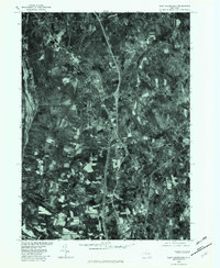
1978 Map of East Greenbush
USGS Topo · Published 1982About this map
East Greenbush and its surrounding townships are shown here during the late 1970s, captured in a detailed orthophotoquad that reveals the transition between expanding suburban residential patterns and the area's agricultural roots. The imagery traces the flow of Papscanee Creek along the western edge, while the interior is defined by the winding paths of the Moordener Kill and Muitzes Kill. This aerial perspective, prepared in cooperation with the Soil Conservation Service, highlights the significant land use variations between the clustered developments of Castleton-on-Hudson and the more dispersed rural settlements like Luther and South Schodack. The map documents the footprint of the landscape just as regional highway infrastructure began to more firmly dictate the growth of communities like Schodack Center and East Schodack.
Find a feature on this map
9 named features on this map. Tap any name to fly to it.
Don’t see what you’re looking for? This feature index may not catch every label — zoom into the map to look around manually.
Map Details
Editions of this 1978 East Greenbush Map
This is the sole edition of this map. No revisions or reprints were ever made.
Other maps of this area

1893 · Troy
USGS Topo · 1:62,500

1893 · Coxsackie
USGS Topo · 1:62,500

1893 · Albany
USGS Topo · 1:62,500

1894 · Coxsackie
USGS Topo · 1:62,500

1895 · Troy
USGS Topo · 1:62,500

1895 · Albany
USGS Topo · 1:62,500

1898 · Albany
USGS Topo · 1:62,500

1898 · Troy
USGS Topo · 1:62,500

1903 · Kinderhook
USGS Topo · 1:62,500

1925 · Troy
USGS Topo · 1:48,000