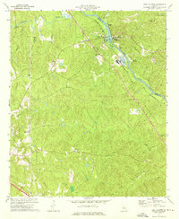
1973 Map of East Juliette
USGS Topo · Published 1975About this map
The Ocmulgee River carves through the landscape where the Jones Co Monroe Co line meets, anchoring the industrial and residential centers of Juliette and East Juliette. In the early 1970s, this river corridor supported a Filtration Plant and Pumping Sta, with Ind Waste Ponds situated on the eastern bank. The Southern railroad line runs parallel to the river, a critical artery for the region's transport economy.
Find a feature on this map
38 named features on this map. Tap any name to fly to it.
Don’t see what you’re looking for? This feature index may not catch every label — zoom into the map to look around manually.
Map Details
Editions of this 1973 East Juliette Map
This is the sole edition of this map. No revisions or reprints were ever made.
Other maps of this area

1951 · Forsyth
USGS Topo · 1:62,500

1953 · Athens
USGS Topo · 1:250,000

1956 · Bolingbroke
USGS Topo · 1:62,500

1956 · Macon
USGS Topo · 1:62,500

1957 · Macon
USGS Topo · 1:250,000

1958 · Macon
USGS Topo · 1:250,000

1958 · Athens
USGS Topo · 1:250,000

1959 · Athens
USGS Topo · 1:250,000

1963 · Athens
USGS Topo · 1:250,000

1964 · Macon
USGS Topo · 1:250,000