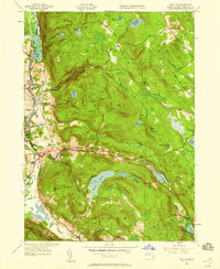
1945 Map of East Lee
USGS Topo · Published 1956About this map
The Housatonic River corridor defines the western edge of this Berkshire County landscape, where the New York New Haven and Hartford railroad tracks parallel the water through Lenoxdale and Lee. In the mid-1940s, the terrain transitions sharply from these river-valley settlements into the high elevations of October Mountain and Washington Mountain. The map shows a region shaped by water management and transit, featuring numerous reservoirs such as the Codding Reservoir and the Sandwash Reservoir, alongside the newly designated path of the Massachusetts Turnpike cutting through East Lee.
Find a feature on this map
58 named features on this map. Tap any name to fly to it.
Don’t see what you’re looking for? This feature index may not catch every label — zoom into the map to look around manually.
Map Details
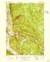
Editions of this 1945 East Lee Map
2 editions found
Other maps of this area

1885 · Sheffield
USGS Topo · 1:62,500

1886 · Becket
USGS Topo · 1:62,500

1888 · Sheffield
USGS Topo · 1:62,500

1888 · Becket
USGS Topo · 1:62,500

1888 · Sandisfield
USGS Topo · 1:62,500

1888 · Pittsfield
USGS Topo · 1:62,500

1890 · Pittsfield
USGS Topo · 1:62,500

1891 · Sheffield
USGS Topo · 1:62,500

1893 · Becket
USGS Topo · 1:62,500

1893 · Sheffield
USGS Topo · 1:62,500