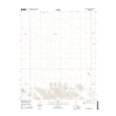
2014 Map of East of Buck Peak
USGS Topo · Published 2014About this map
The Mohawk Valley dominates the northern expanse of this 2014 survey, a region defined by its austere desert landscape and dramatic elevation changes. In the southern portion of the quadrangle, the terrain rises sharply into the jagged peaks of the Cabeza Prieta Mountains, which overlook the arid reaches of the Tule Desert. This area of Yuma County is characterized by vast drainage patterns and alluvial fans that spill out from the mountain range toward the valley floor. Between these two major geological features lie the Devil Hills, small volcanic or erosional remnants that provide a distinct landmark in the middle of the desert transition. The map captures a section of the American Southwest that remains largely undeveloped, preserving the raw topographical relationships between the basin and the range.
Find a feature on this map
10 named features on this map. Tap any name to fly to it.
Don’t see what you’re looking for? This feature index may not catch every label — zoom into the map to look around manually.
Map Details
Editions of this 2014 East of Buck Peak Map
This is the sole edition of this map. No revisions or reprints were ever made.
Other maps of this area
1926 · Mohawk
USGS Topo · 1:62,500
1927 · Kim
USGS Topo · 1:62,500
1928 · Mohawk
USGS Topo · 1:62,500
1931 · Kim
USGS Topo · 1:62,500

1953 · Ajo
USGS Topo · 1:250,000

1957 · Ajo
USGS Topo · 1:250,000

1958 · Ajo
USGS Topo · 1:250,000

1962 · Ajo
USGS Topo · 1:250,000

1963 · Ajo
USGS Topo · 1:250,000
1965 · Cabeza Prieta Peak
USGS Topo · 1:62,500