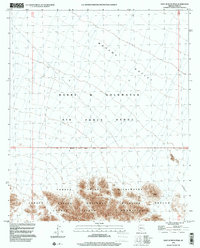
1996 Map of East of Buck Peak
USGS Topo · Published 2000About this map
The Cabeza Prieta Mountains dominate the southern landscape of this 1996 survey, where the high peaks and ridge lines meet the expansive Tule Desert to the east. This region is defined by overlapping layers of federal land management, reflecting the dual-purpose nature of the Arizona borderlands. Much of the northern portion is occupied by the Barry M Goldwater Air Force Range, a vast military training ground that transitions into the protected conservation lands of the Cabeza Prieta National Wildlife Refuge. The map illustrates the striking intersection of the desert floor in the Mohawk Valley with the protected wilderness zones. The Wilderness and Wildlife Refuge Boundary serves as a critical marker between military airspace use and the preserved habitat of the Cabeza Prieta Wilderness, capturing a snapshot of the Sonoran Desert's complex administration at the end of the century.
Find a feature on this map
11 named features on this map. Tap any name to fly to it.
Don’t see what you’re looking for? This feature index may not catch every label — zoom into the map to look around manually.
Map Details
Editions of this 1996 East of Buck Peak Map
This is the sole edition of this map. No revisions or reprints were ever made.
Other maps of this area

1926 · Mohawk
USGS Topo · 1:62,500

1927 · Kim
USGS Topo · 1:62,500

1928 · Mohawk
USGS Topo · 1:62,500

1931 · Kim
USGS Topo · 1:62,500

1953 · Ajo
USGS Topo · 1:250,000

1957 · Ajo
USGS Topo · 1:250,000

1958 · Ajo
USGS Topo · 1:250,000

1962 · Ajo
USGS Topo · 1:250,000

1963 · Ajo
USGS Topo · 1:250,000

1965 · Cabeza Prieta Peak
USGS Topo · 1:62,500