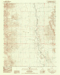
1987 Map of East of Deadman Pass
USGS Topo · Published 1987About this map
The Amargosa River corridor cuts through the arid landscape of Inyo County, showing a complex network of ephemeral channels and flood control features like the Dikes and a smaller Dike found further south. This 1987 survey captures the eastern approaches to the Greenwater Range, where the topography rises sharply from the river basin. Traces of industrial history are etched into the terrain, most notably the Old RR Grade that follows the river's path, providing a clear reference for those studying historical transportation routes through the Mojave. Scattered Prospects and a Borrow Pit indicate localized mining and material extraction efforts in an area defined more by its natural desert forms and township boundaries than by permanent settlements.
Find a feature on this map
14 named features on this map. Tap any name to fly to it.
Don’t see what you’re looking for? This feature index may not catch every label — zoom into the map to look around manually.
Map Details
Editions of this 1987 East of Deadman Pass Map
This is the sole edition of this map. No revisions or reprints were ever made.
Other maps of this area

1908 · Furnace Creek
USGS Topo · 1:250,000

1910 · Furnace Creek
USGS Topo · 1:250,000

1933 · Avawatz Mountains
USGS Topo · 1:250,000

1940 · Eagle Tank
USGS Topo · 1:62,500

1947 · Trona
USGS Topo · 1:250,000

1948 · Trona
USGS Topo · 1:250,000

1948 · Death Valley
USGS Topo · 1:250,000

1950 · Tecopa
USGS Topo · 1:62,500

1951 · Tecopa
USGS Topo · 1:62,500

1951 · Eagle Mtn
USGS Topo · 1:62,500