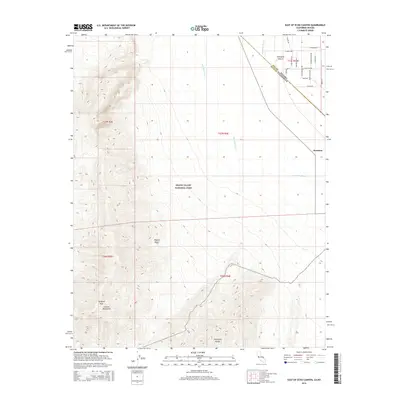
2015 Map of East of Echo Canyon
USGS Topo · Published 2015About this map
Pyramid Peak and the high ridges of the Funeral Mountains dominate the western portion of this landscape, where the boundary of Death Valley National Park marks the transition from protected wilderness to the valley floor. The eastern half is defined by the arid expanse of the Amargosa Desert, where the Amargosa River and Fortymite Wash thread through the terrain. In the northeast, a grid of local roads including Cottonwood Rd and Desert Storm Rd indicates rural development near the Amargosa Range. The small settlement of Scranton is situated along the eastern edge, serving as a point of human activity in the vast Mojave Desert environment. This survey captures the intersection of dramatic topography and the persistent efforts to establish residency in one of the nation's most challenging climates.
Find a feature on this map
30 named features on this map. Tap any name to fly to it.
Don’t see what you’re looking for? This feature index may not catch every label — zoom into the map to look around manually.
Map Details
Editions of this 2015 East of Echo Canyon Map
This is the sole edition of this map. No revisions or reprints were ever made.
Other maps of this area

1908 · Furnace Creek
USGS Topo · 1:250,000

1910 · Furnace Creek
USGS Topo · 1:250,000
1942 · Skull Mountain
USGS Topo · 1:125,000
1942 · Bullfrog
USGS Topo · 1:125,000

1948 · Death Valley
USGS Topo · 1:250,000
1952 · Ash Meadows
USGS Topo · 1:62,500
1952 · Ryan
USGS Topo · 1:62,500
1952 · Big Dune
USGS Topo · 1:62,500

1954 · Death Valley
USGS Topo · 1:250,000

1956 · Death Valley
USGS Topo · 1:250,000