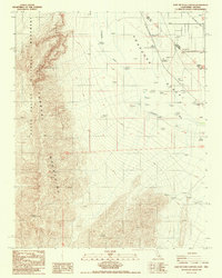
1987 Map of East of Echo Canyon
USGS Topo · Published 1987About this map
The Funeral Mountains dominate the western horizon of this survey, where the desert floor rises sharply toward Pyramid Peak. This arid landscape is defined by the ephemeral Amargosa River as it cuts through the Amargosa Desert, crossing a region heavily shaped by historical surveying and industrial transit. A significant portion of the western terrain falls within the Death Valley National Monument, while the eastern portion reveals the legacy of early infrastructure. Traces of the Old Railroad Grade and various scattered prospects indicate the mining and transport history of the California-Nevada borderlands. The map also preserves the Von Schmidt Line (1873), reflecting the complex history of state boundary disputes in this remote corridor. Near the eastern edge, the small settlement of Scranton sits at the base of the mountains, positioned among a network of 4wd tracks and land-survey monuments.
Find a feature on this map
17 named features on this map. Tap any name to fly to it.
Don’t see what you’re looking for? This feature index may not catch every label — zoom into the map to look around manually.
Map Details
Editions of this 1987 East of Echo Canyon Map
This is the sole edition of this map. No revisions or reprints were ever made.
Other maps of this area

1908 · Furnace Creek
USGS Topo · 1:250,000

1910 · Furnace Creek
USGS Topo · 1:250,000

1942 · Skull Mountain
USGS Topo · 1:125,000

1942 · Bullfrog
USGS Topo · 1:125,000

1948 · Death Valley
USGS Topo · 1:250,000

1952 · Ash Meadows
USGS Topo · 1:62,500

1952 · Ryan
USGS Topo · 1:62,500

1952 · Big Dune
USGS Topo · 1:62,500

1954 · Death Valley
USGS Topo · 1:250,000

1956 · Death Valley
USGS Topo · 1:250,000