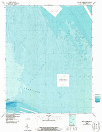
1986 Map of East of Hampton
USGS Topo · Published 1987About this map
Chesapeake Bay bathymetry dominates this 1980s nautical survey, revealing the complex underwater topography of the Virginia coastline. The map focuses heavily on the submerged landscape of the Horseshoe and the deeper navigation channels of Thimble Shoal. Unlike typical topographic maps, this bathymetric study emphasizes the depth gradients and contours of the seabed as compiled by the National Ocean Service. It highlights the human impact on the marine environment through the labeling of a Spoil Area Discontinued and a Disposal Area Discontinued, indicating shifts in maritime waste management and dredging practices. This chart is a specialized look at the maritime gateway to the Hampton Roads region during the late twentieth century.
Find a feature on this map
6 named features on this map. Tap any name to fly to it.
Don’t see what you’re looking for? This feature index may not catch every label — zoom into the map to look around manually.
Map Details
Editions of this 1986 East of Hampton Map
This is the sole edition of this map. No revisions or reprints were ever made.
Other maps of this area

1907 · Norfolk
USGS Topo · 1:125,000

1907 · Hampton
USGS Topo · 1:62,500

1918 · Cape Henry
USGS Topo · 1:62,500

1919 · Cape Henry
USGS Topo · 1:62,500

1921 · Newport News
USGS Topo · 1:62,500

1943 · Elliots Creek
USGS Topo · 1:25,000

1943 · Richmond
USGS Topo · 1:250,000

1944 · Hampton
USGS Topo · 1:24,000

1944 · Messick
USGS Topo · 1:24,000

1948 · Ocean View
USGS Topo · 1:24,000