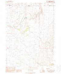
1989 Map of East of Jackpot
USGS Topo · Published 1989About this map
Warm Springs and Deer Springs emerge from the high desert terrain of the Great Basin in this late-twentieth-century study of the Nevada-Idaho border. The landscape is defined by a series of intermittent and perennial drainages including Lost Shoshone Creek and Cedar Creek, which carve through the high plateaus of Elko County. This 1989 provisional survey captures the remote character of the region just south of the state line, where water sources like Willow Creek and Trout Creek were vital landmarks for navigation and land use in a sparsely settled ranching and grazing environment. The intersection of the Twin Falls and Elko County lines with the Idaho-Nevada boundary provides a clear look at how administrative borders were placed against the natural features of the high desert floor.
Find a feature on this map
9 named features on this map. Tap any name to fly to it.
Don’t see what you’re looking for? This feature index may not catch every label — zoom into the map to look around manually.
Map Details
Editions of this 1989 East of Jackpot Map
This is the sole edition of this map. No revisions or reprints were ever made.
Other maps of this area

1955 · Twin Falls
USGS Topo · 1:250,000

1955 · Wells
USGS Topo · 1:250,000

1957 · Delaplain
USGS Topo · 1:62,500

1958 · Wells
USGS Topo · 1:250,000

1958 · Twin Falls
USGS Topo · 1:250,000

1961 · Wells
USGS Topo · 1:250,000

1961 · Gollaher Mountain
USGS Topo · 1:62,500

1977 · Big Creek Ranch
USGS Topo · 1:24,000

1977 · Magic Hot Springs
USGS Topo · 1:24,000
1978 · Meteor
USGS Topo · 1:24,000