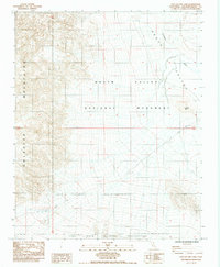
1984 Map of East of Owl Lake
USGS Topo · Published 1984About this map
Owl Hole Springs serves as a vital water source in this arid corner of the Mojave Desert, situated at the base of the Owlhead Mountains. This 1984 survey documents a transition zone where the southern reaches of Death Valley National Monument meet the northern boundary of the Fort Irwin Military Reservation. The landscape is defined by alluvial fans and desert washes, most notably the path of the Amargosa River as it flows toward the valley floor. Relief is provided by prominent landmarks like Round Mtn, while the map records the network of 4wd tracks and primitive Road ways that once provided the only access through this remote terrain. The presence of both military and national monument boundaries reflects the complex land management of the California desert during the late twentieth century.
Find a feature on this map
11 named features on this map. Tap any name to fly to it.
Don’t see what you’re looking for? This feature index may not catch every label — zoom into the map to look around manually.
Map Details
Editions of this 1984 East of Owl Lake Map
This is the sole edition of this map. No revisions or reprints were ever made.
Other maps of this area

1933 · Avawatz Mountains
USGS Topo · 1:250,000

1947 · Trona
USGS Topo · 1:250,000

1948 · Trona
USGS Topo · 1:250,000

1948 · Leach Lake
USGS Topo · 1:62,500

1948 · Avawatz Pass
USGS Topo · 1:62,500

1950 · Confidence Hills
USGS Topo · 1:62,500

1951 · Avawatz Pass
USGS Topo · 1:62,500
1951 · Leach Lake
USGS Topo · 1:62,500

1951 · Shoshone
USGS Topo · 1:62,500

1953 · Trona
USGS Topo · 1:250,000