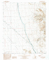
1990 Map of East of Utting
USGS Topo · Published 1990About this map
Granite Wash Mountains dominate the eastern edge of this desert landscape, where numerous mining features such as Open Pit Mine, Mine Shaft, and various Prospects are clustered. The terrain transitions westward into the expansive Ran Egras Plain, a flat area marked by the small settlement of McVay and several water management features. The most prominent modern infrastructure is the Hayden-Rhodes Aqueduct, which cuts diagonally across the quadrangle. This massive engineering project is accompanied by a Road On Levee, a Check Station, and a series of Check Dams designed to manage the unpredictable flow of desert washes like Big Granite Wash and Bouse Wash. A remote Landing Strip and specialized wildlife features like a Guzzler further characterize the human adaptations to this arid Arizona environment.
Find a feature on this map
26 named features on this map. Tap any name to fly to it.
Don’t see what you’re looking for? This feature index may not catch every label — zoom into the map to look around manually.
Map Details
Editions of this 1990 East of Utting Map
This is the sole edition of this map. No revisions or reprints were ever made.
Other maps of this area

1942 · Vicksburg
USGS Topo · 1:250,000

1954 · Phoenix
USGS Topo · 1:250,000

1957 · Phoenix
USGS Topo · 1:250,000

1958 · Phoenix
USGS Topo · 1:250,000

1960 · Phoenix
USGS Topo · 1:250,000

1961 · Salome
USGS Topo · 1:62,500

1961 · Hope
USGS Topo · 1:62,500
1962 · Utting
USGS Topo · 1:62,500

1962 · Vicksburg
USGS Topo · 1:62,500

1969 · Phoenix
USGS Topo · 1:250,000