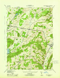
1945 Map of East Springfield
USGS Topo · Published 1945About this map
The Cherry Valley Turnpike cuts through the rolling highlands of northeastern Otsego County, anchoring a series of small 1940s hamlets and agricultural crossroads. Middle Village, East Springfield, and Springfield Four Corners form a tight cluster of settlement along this historic corridor, supported by the Springfield Ch and several local burying grounds like Springfield Cem. To the southeast, the village of Cherry Valley sits at the base of the steep Cherry Valley ridge, where the D & H railroad tracks follow the valley floor. The map records a rural educational landscape transitioning toward modernization, still showing dispersed local institutions such as Continental School, Stanley School, and School No 9. High points like Shankley Mtn and Mt Wellington overlook a landscape of mixed woods and wetlands, including Cedar Swamp and the headwaters of Hayden Creek.
Find a feature on this map
45 named features on this map. Tap any name to fly to it.
Don’t see what you’re looking for? This feature index may not catch every label — zoom into the map to look around manually.
Map Details
Editions of this 1945 East Springfield Map
This is the sole edition of this map. No revisions or reprints were ever made.
Other maps of this area

1898 · Canajoharie
USGS Topo · 1:62,500

1900 · Canajoharie
USGS Topo · 1:62,500

1902 · Canajoharie
USGS Topo · 1:62,500

1903 · Richfield Springs
USGS Topo · 1:62,500

1904 · Richmondville
USGS Topo · 1:62,500

1907 · Cooperstown
USGS Topo · 1:62,500

1909 · Cooperstown
USGS Topo · 1:62,500

1943 · Jordanville
USGS Topo · 1:24,000

1943 · South Valley
USGS Topo · 1:24,000

1943 · Richfield Springs
USGS Topo · 1:24,000