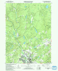
1993 Map of East Stroudsburg
USGS Topo · Published 1993About this map
East Stroudsburg serves as the focal point of this 1993 study, where the developed streets and institutional landmarks like the High Sch and JM Hill Sch meet the surrounding forests and mountain lakes. The landscape is defined by the convergence of Brodhead Creek and Sambo Creek, a drainage system that has historically supported both local industry and seasonal recreation. Pockets of religious life are scattered throughout the hills, evidenced by the Mt Zion Ch near Mt Zion and the Holy Trinity Ch to the east.
Find a feature on this map
75 named features on this map. Tap any name to fly to it.
Don’t see what you’re looking for? This feature index may not catch every label — zoom into the map to look around manually.
Map Details
Editions of this 1993 East Stroudsburg Map
This is the sole edition of this map. No revisions or reprints were ever made.
Other maps of this area

1891 · Delaware Water Gap
USGS Topo · 1:62,500

1893 · Delaware Water Gap
USGS Topo · 1:62,500

1914 · Wind Gap
USGS Topo · 1:62,500

1916 · Wind Gap
USGS Topo · 1:62,500

1919 · Pocono
USGS Topo · 1:62,500

1921 · Pocono
USGS Topo · 1:62,500

1923 · Pocono
USGS Topo · 1:62,500

1924 · Bushkill
USGS Topo · 1:48,000

1936 · Delaware Water Gap
USGS Topo · 1:48,000

1941 · Delaware Water Gap
USGS Topo · 1:62,500
Featured Places
- Paradise Township, PA
- Analomink, Stroud Township
- Marshalls Creek, Smithfield Township
- Middle Smithfield Township, PA
- Arlington Heights, Stroud Township