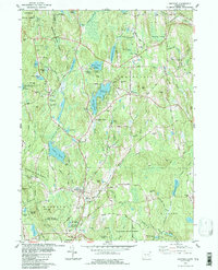
1983 Map of Eastford
USGS Topo · Published 1984About this map
The town of Eastford and its surrounding hill country define this detailed topographic portrait of northeastern Connecticut during the early 1980s. The landscape is characterized by a high density of named water bodies and protected lands, notably the Nipmuck State Forest in the north and the extensive Natchaug State Forest to the south. Small, historic crossroads like Woodstock Valley and Kenyonville are shown alongside active community landmarks such as Camp Woodstock and the Windham-Tolland 4 H Camp on Taft Pond Road.
Find a feature on this map
113 named features on this map. Tap any name to fly to it.
Don’t see what you’re looking for? This feature index may not catch every label — zoom into the map to look around manually.
Map Details
Editions of this 1983 Eastford Map
This is the sole edition of this map. No revisions or reprints were ever made.
Other maps of this area

1887 · Brookfield
USGS Topo · 1:62,500

1889 · Webster
USGS Topo · 1:62,500

1889 · Putnam
USGS Topo · 1:62,500

1890 · Brookfield
USGS Topo · 1:62,500

1892 · Woodstock
USGS Topo · 1:62,500

1892 · Webster
USGS Topo · 1:62,500

1893 · Putnam
USGS Topo · 1:62,500

1893 · Brookfield
USGS Topo · 1:62,500

1908 · Quinsigamond
USGS Topo · 1:125,000

1908 · Ware
USGS Topo · 1:125,000