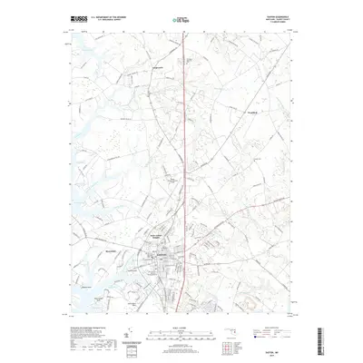
2019 Map of Easton
USGS Topo · Published 2019About this map
The historic county seat of Easton dominates the central landscape, revealing a dense network of residential streets and historic sites like the Third Haven Meeting Burial Ground. The map highlights the town's connection to the water through Easton Point, where the Tred Avon River meets the urban edge, and Glebe Creek carves into the western landscape near Bloomfield. To the north and east, the transition to the rural Eastern Shore is marked by smaller settlements like Longwoods and Woodland, alongside significant landmarks such as the Easton Airport/Newnam Field. The geography is defined by a dendritic system of creeks and runs, including Potts Mill Creek and Goldsborough Creek, which flow toward the Miles River. Genealogists will find interest in the numerous cemeteries recorded, such as Spring Hill Cem and All Saints Cem, which ground the modern layout in the area's deep family history.
Find a feature on this map
166 named features on this map. Tap any name to fly to it.
Don’t see what you’re looking for? This feature index may not catch every label — zoom into the map to look around manually.
Map Details
Editions of this 2019 Easton Map
This is the sole edition of this map. No revisions or reprints were ever made.
Other maps of this area

1898 · Choptank
USGS Topo · 1:125,000

1904 · St. Michaels
USGS Topo · 1:62,500

1904 · Oxford
USGS Topo · 1:62,500

1905 · Denton
USGS Topo · 1:62,500

1905 · Hurlock
USGS Topo · 1:62,500

1908 · Choptank
USGS Topo · 1:125,000

1942 · Oxford
USGS Topo · 1:31,680
1942 · Queenstown
USGS Topo · 1:24,000
1942 · Easton
USGS Topo · 1:24,000
1942 · Wye Mills
USGS Topo · 1:24,000