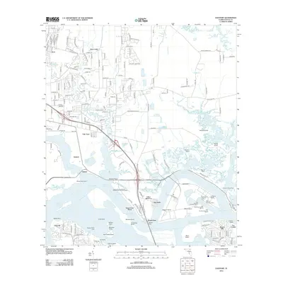
2012 Map of Eastport
USGS Topo · Published 2012About this map
The Saint Johns River dominates this portion of Duval County, serving as a critical artery for the maritime infrastructure north of Jacksonville. Industrial development is anchored by the Jacksonville Port Authority Ed Austin Marine Terminal Wharf, while residential pockets like Dames Point Manor, New Berlin, and Eastport sit nestled between the river's winding reaches. Historical continuity is visible at Yellow Bluff Fort and the Dunn Creek Cem, marking long-standing settlement along the northern banks. The landscape is a complex network of named islands and marshes, including Blount Island and Browns Island, which are partitioned by deep-water ranges and channels such as the Blount Island Channel and Broward Point Turn. This topography illustrates the conversion of a low-lying riverine environment into a modern shipping and logistics hub.
Find a feature on this map
74 named features on this map. Tap any name to fly to it.
Don’t see what you’re looking for? This feature index may not catch every label — zoom into the map to look around manually.
Map Details
Editions of this 2012 Eastport Map
This is the sole edition of this map. No revisions or reprints were ever made.
Other maps of this area

1918 · St Marys
USGS Topo · 1:62,500

1918 · Jacksonville
USGS Topo · 1:62,500

1918 · Mayport
USGS Topo · 1:62,500

1919 · Fernandina
USGS Topo · 1:62,500

1919 · St Marys
USGS Topo · 1:62,500

1944 · Fernandina
USGS Topo · 1:62,500

1948 · Jacksonville
USGS Topo · 1:250,000

1948 · Jacksonville Beach
USGS Topo · 1:24,000

1948 · Eastport
USGS Topo · 1:24,000

1949 · Jacksonville Beach
USGS Topo · 1:24,000
Featured Places
- Jacksonville, FL
- Dames Point Manor, Jacksonville
- Beacon Hills, Jacksonville
- Fort Caroline, Jacksonville
- New Berlin, Jacksonville