
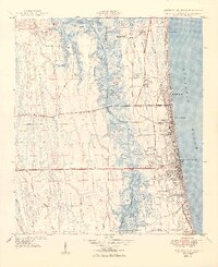
1949 Map of Jacksonville Beach
USGS Topo · Published 1949About this map
The growing coastal communities of Atlantic Beach, Neptune Beach, and Jacksonville Beach line the Atlantic shore in the years following the war. This survey captures a significant moment in the region's infrastructure, showing Beach Boulevard in the midst of development, providing a new arterial link across the marshy wetlands. Inland from the sandy beaches, the landscape is defined by the Intracoastal Waterway and the winding course of Pablo Creek, which separates the barrier island settlements from the rural pine islands and hammocks like Crying Child Island and Seven Pines Island. Local history is preserved in the location of several burial grounds, including the Tillotson and Mayport cemeteries. Significant landmarks of the era include Fletcher High School, the Filtration Plant, and the Ponte Vedra Golf Course near the southern border with St Johns County.
Find a feature on this map
63 named features on this map. Tap any name to fly to it.
Don’t see what you’re looking for? This feature index may not catch every label — zoom into the map to look around manually.
Map Details
Editions of this 1949 Jacksonville Beach Map
2 editions found
Other maps of this area

1917 · Orange Park
USGS Topo · 1:62,500

1918 · Jacksonville
USGS Topo · 1:62,500

1918 · Orange Park
USGS Topo · 1:62,500

1918 · Palm Valley
USGS Topo · 1:62,500

1918 · Mayport
USGS Topo · 1:62,500

1948 · Jacksonville
USGS Topo · 1:250,000

1948 · Jacksonville Beach
USGS Topo · 1:24,000

1948 · Eastport
USGS Topo · 1:24,000

1950 · Arlington
USGS Topo · 1:24,000
1950 · Mayport
USGS Topo · 1:24,000