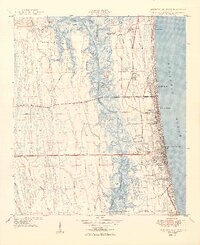
1949 Map of Jacksonville Beach
USGS Topo · Published 1949About this map
Jacksonville Beach and the neighboring coastal communities of Atlantic Beach and Neptune Beach are shown here during a period of significant post-war infrastructure development. While the oceanfront is already densely plotted with a street grid extending to Manhattan Beach, the interior landscape remains a complex network of marsh and hammocks. Notable among these are Seven Pines Island and Crying Child Island situated within the wide reach of Pablo Creek and the Intracoastal Waterway.
Find a feature on this map
67 named features on this map. Tap any name to fly to it.
Don’t see what you’re looking for? This feature index may not catch every label — zoom into the map to look around manually.
Map Details
Editions of this 1949 Jacksonville Beach Map
2 editions found
Other maps of this area

1917 · Orange Park
USGS Topo · 1:62,500

1918 · Jacksonville
USGS Topo · 1:62,500

1918 · Orange Park
USGS Topo · 1:62,500

1918 · Palm Valley
USGS Topo · 1:62,500

1918 · Mayport
USGS Topo · 1:62,500

1948 · Jacksonville
USGS Topo · 1:250,000

1948 · Jacksonville Beach
USGS Topo · 1:24,000

1948 · Eastport
USGS Topo · 1:24,000

1949 · Jacksonville Beach
USGS Topo · 1:24,000

1950 · Arlington
USGS Topo · 1:24,000