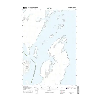
2014 Map of Eastport OE E
USGS Topo · Published 2014About this map
The easternmost reaches of Maine are captured in this 2014 survey, highlighting the complex shoreline where the United States and Canada maritime border converges. The settlement of Eastport occupies a prominent position on the coast, showing a detailed street grid that includes Washington St, Clark St, and Barron Rd. This nautical landscape is defined by its numerous unnamed islands and peninsulas, reflecting the high-tide environment of the Washington County coast. The mapping of the international boundary through the open waters provides a clear view of the territorial limits between the two nations in this maritime corridor.
Find a feature on this map
11 named features on this map. Tap any name to fly to it.
Don’t see what you’re looking for? This feature index may not catch every label — zoom into the map to look around manually.
Map Details
Editions of this 2014 Eastport OE E Map
This is the sole edition of this map. No revisions or reprints were ever made.
Other maps of this area

1907 · Eastport
USGS Topo · 1:48,000

1908 · Eastport
USGS Topo · 1:62,500

1929 · Robbinston
USGS Topo · 1:48,000

1931 · Robbinston
USGS Topo · 1:62,500

1943 · Eastport
USGS Topo · 1:62,500

1945 · Eastport
USGS Topo · 1:62,500

1949 · Robbinston
USGS Topo · 1:24,000

1949 · Eastport
USGS Topo · 1:24,000

1949 · West Lubec
USGS Topo · 1:24,000
1949 · Lubec
USGS Topo · 1:24,000