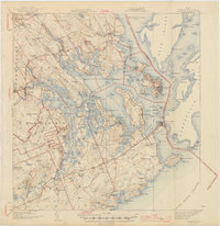
1945 Map of Eastport
USGS Topo · Published 1945About this map
Eastport and the surrounding islands of Cobscook Bay define this coastal landscape at the international boundary between the United States and Canada. The map illustrates a complex network of maritime and terrestrial infrastructure, including the Maine Central RR which terminates at Eastport, connecting the port to Ayers Junction. On the western shore, the extensive Moosehorn National Wildlife Refuge provides a significant conservation anchor near Dennysville. Local life in the mid-1940s is traced through numerous rural institutions like Big Hill Sch and Hibbard Sch, alongside small coastal villages such as Lubec and Whiting. The shoreline is deeply indented by Whiting Bay, Dennys Bay, and South Bay, reflecting the region's reliance on tidal waters and traditional industries. Across the Lubec Channel, the settlement of Welshpool sits on the Canadian side of the border, illustrating the close proximity of the two nations at the Grand Manan Channel.
Find a feature on this map
197 named features on this map. Tap any name to fly to it.
Don’t see what you’re looking for? This feature index may not catch every label — zoom into the map to look around manually.
Map Details
Editions of this 1945 Eastport Map
2 editions found

Other maps of this area

1907 · Eastport
USGS Topo · 1:48,000

1908 · Eastport
USGS Topo · 1:62,500

1917 · Cutler
USGS Topo · 1:62,500

1918 · Machias
USGS Topo · 1:62,500

1918 · Cutler
USGS Topo · 1:62,500

1929 · Calais
USGS Topo · 1:48,000

1929 · Robbinston
USGS Topo · 1:48,000

1931 · Robbinston
USGS Topo · 1:62,500

1932 · Calais
USGS Topo · 1:62,500

1941 · Machias
USGS Topo · 1:62,500