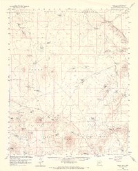
1960 Map of Ebert Mtn
USGS Topo · Published 1969About this map
The high plateau of the Kaibab National Forest dominates this northern Arizona landscape, where water security was the primary concern for remote livestock operations in the late 1950s. The map reveals an extensive system of man-made water catchments, often named for local wildlife or topographic features, including Tarantula Tank, Dog Knobs Lake, and Pearl Harbor Tank. Settlement is sparse and centered on established ranching outposts such as Dent and Sayer Ranch and Nagiller Ranch. The physical geography is defined by volcanic features like the cinder cone of Ebert Mtn, the flat-topped Mesa Butte, and the distinct profile of Slate Mtn near the southern boundary. A notable industrial marker is the Cinder Pit near Red Mtn, signifying the local extraction of volcanic materials. The presence of a prominent Pipeline cutting across the landscape suggests the logistical challenges of supporting this arid region's economy.
Find a feature on this map
50 named features on this map. Tap any name to fly to it.
Don’t see what you’re looking for? This feature index may not catch every label — zoom into the map to look around manually.
Map Details
Editions of this 1960 Ebert Mtn Map
3 editions found
Other maps of this area

1886 · San Francisco Mtns
USGS Topo · 1:250,000

1886 · Chino
USGS Topo · 1:250,000

1891 · San Francisco Mtns
USGS Topo · 1:250,000

1891 · Chino
USGS Topo · 1:250,000

1894 · San Francisco Mtns
USGS Topo · 1:250,000

1899 · San Francisco Mtns
USGS Topo · 1:250,000

1908 · Flagstaff
USGS Topo · 1:125,000

1912 · Flagstaff
USGS Topo · 1:125,000

1922 · Williams
USGS Topo · 1:125,000

1947 · Flagstaff
USGS Topo · 1:250,000