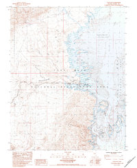
1983 Map of Echo Bay
USGS Topo · Published 1984About this map
Echo Bay serves as a focal point of activity along the western edge of the Lake Mead Overton Arm in the early 1980s. This desert landscape is defined by the meeting of the Virgin River with the reservoir, where specific water elevations such as the Normal Pool Elevation 366M dictate the shoreline of features like Bluepoint Bay and Calico Bay. The map reveals the infrastructure of recreation and remote residency, from the Trailer Park and Echo Mills to the Boat Ramp and nearby Landing Strip.
Find a feature on this map
37 named features on this map. Tap any name to fly to it.
Don’t see what you’re looking for? This feature index may not catch every label — zoom into the map to look around manually.
Map Details
Editions of this 1983 Echo Bay Map
This is the sole edition of this map. No revisions or reprints were ever made.
Other maps of this area

1886 · Saint Thomas
USGS Topo · 1:250,000

1893 · Saint Thomas
USGS Topo · 1:250,000

1926 · Bonelli
USGS Topo · 1:96,000

1926 · Boulder Canyon
USGS Topo · 1:96,000

1953 · Muddy Peak
USGS Topo · 1:62,500

1953 · Overton Beach
USGS Topo · 1:62,500

1953 · Hoover Dam
USGS Topo · 1:62,500

1953 · Virgin Basin
USGS Topo · 1:62,500

1954 · Las Vegas
USGS Topo · 1:250,000

1957 · Las Vegas
USGS Topo · 1:250,000