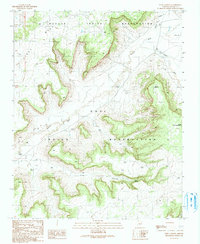
1990 Map of Echo Canyon
USGS Topo · Published 1991About this map
First Mesa dominates this 1990 topographical study, where the high desert terrain of the Hopi Indian Reservation meets the Navajo Indian Reservation. The map details a complex network of seasonal drainage and water management, highlighting numerous check dams constructed to control runoff throughout the arid landscape. Polacca Wash and Burnt Corn Wash carve through the mesa country, while Echo Canyon and Cienega Canyon define the southern reaches of the quadrangle. Significant water sources for the era are carefully noted, including Echo Spring, a water tank, and a flowing well. From the prominent overlook at Gum Point to the winding course of Tse Chizzi Wash, the map provides an essential record of the physical geography and land-use boundaries in this portion of the American Southwest during the late twentieth century.
Find a feature on this map
14 named features on this map. Tap any name to fly to it.
Don’t see what you’re looking for? This feature index may not catch every label — zoom into the map to look around manually.
Map Details
Editions of this 1990 Echo Canyon Map
This is the sole edition of this map. No revisions or reprints were ever made.
Other maps of this area

1883 · Marsh Pass
USGS Topo · 1:250,000

1883 · Tusayan
USGS Topo · 1:250,000

1886 · Tusayan
USGS Topo · 1:250,000

1892 · Marsh Pass
USGS Topo · 1:250,000

1947 · Flagstaff
USGS Topo · 1:250,000

1954 · Flagstaff
USGS Topo · 1:250,000

1956 · Marble Canyon
USGS Topo · 1:250,000

1958 · Flagstaff
USGS Topo · 1:250,000

1959 · Marble Canyon
USGS Topo · 1:250,000

1960 · Flagstaff
USGS Topo · 1:250,000