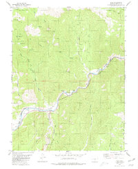
1980 Map of Echo
USGS Topo · Published 1980About this map
The Arkansas River serves as the primary corridor for movement and activity through this portion of Fremont County, dictated by the steep geography of Echo Canyon. The Denver and Rio Grande Western Railroad tracks follow the river's path, marking a vital transportation artery alongside the small settlement of Echo. Higher elevations are defined by resource extraction and water management, evidenced by numerous prospects and quarries, as well as a series of catchments including Wild Oat Reservoir and Shoe Tree Reservoir. The presence of an Old Grade near Texas Creek suggests former industrial or rail alignments now superseded. Between the high plateau of Table Mountain and the deep gulches, the landscape is a network of Jeep Trails and seasonal drainage routes like Reese Gulch and Antelope Gulch.
Find a feature on this map
33 named features on this map. Tap any name to fly to it.
Don’t see what you’re looking for? This feature index may not catch every label — zoom into the map to look around manually.
Map Details
Editions of this 1980 Echo Map
This is the sole edition of this map. No revisions or reprints were ever made.
Other maps of this area

1889 · Canon City
USGS Topo · 1:125,000

1892 · Canon City
USGS Topo · 1:125,000

1894 · Pikes Peak
USGS Topo · 1:125,000

1901 · Pikes Peak
USGS Topo · 1:125,000

1942 · Cover Mtn.
USGS Topo · 1:62,500

1948 · Cover Mtn.
USGS Topo · 1:62,500

1954 · Pueblo
USGS Topo · 1:250,000

1957 · Pueblo
USGS Topo · 1:250,000

1958 · Pueblo
USGS Topo · 1:250,000

1959 · Black Mountain
USGS Topo · 1:62,500