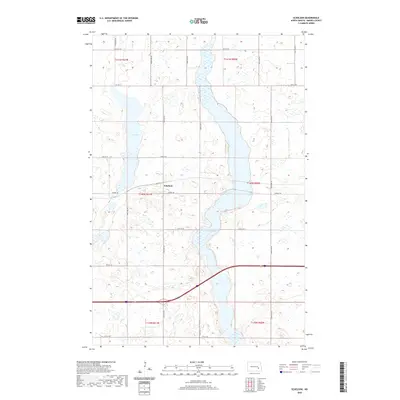
2020 Map of Eckelson
USGS Topo · Published 2020About this map
Eckelson sits at the heart of this Barnes County landscape, serving as a primary point of interest within a region characterized by its glacial water bodies and systematic road grid. The map depicts a territory defined by two major aquatic features: the elongated Eckelson Lake which stretches through the central sections, and Fox Lake to the west. These lakes are surrounded by numerous smaller wetlands and depressions typical of the North Dakota prairie. The infrastructure here is heavily defined by the Public Land Survey System, with roads like 32nd St SE and Airport Road following section lines across the townships of t140n r61w and t140n r60w. The convergence of Co Hwy 3 and 2nd Ave near the settlement highlights the historical importance of this small community as a local transportation node.
Find a feature on this map
18 named features on this map. Tap any name to fly to it.
Don’t see what you’re looking for? This feature index may not catch every label — zoom into the map to look around manually.
Map Details
Editions of this 2020 Eckelson Map
This is the sole edition of this map. No revisions or reprints were ever made.
Other maps of this area

1897 · Eckelson
USGS Topo · 1:125,000

1952 · New Rockford
USGS Topo · 1:250,000

1953 · Jamestown
USGS Topo · 1:250,000

1956 · New Rockford
USGS Topo · 1:250,000

1956 · Jamestown
USGS Topo · 1:250,000

1961 · Leal
USGS Topo · 1:24,000

1961 · Rogers
USGS Topo · 1:24,000

1970 · Eckelson
USGS Topo · 1:24,000
1970 · Clementsville
USGS Topo · 1:24,000
1970 · Spiritwood
USGS Topo · 1:24,000