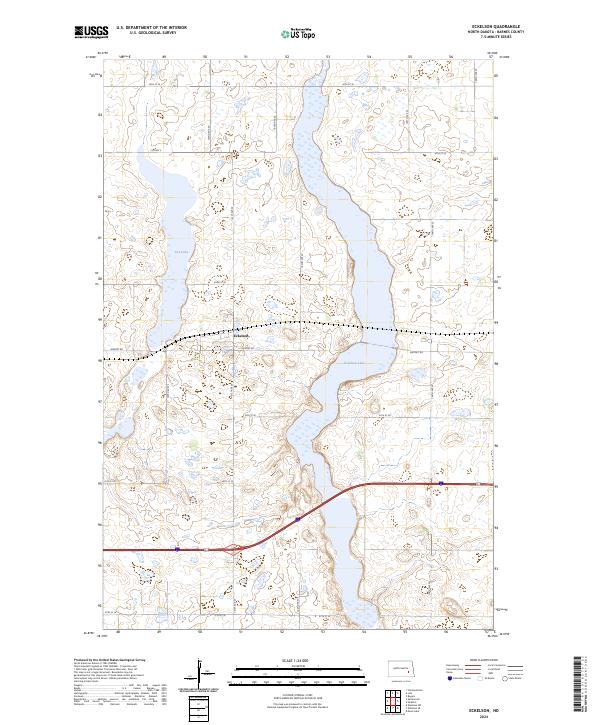
2024 Map of Eckelson
USGS Topo · Published 2024About this map
Eckelson serves as the central focal point of this landscape, situated along the crossroads of Airport Rd and local connectors. The terrain is defined by its significant hydrography, notably the elongated Eckelson Lake which spans several sections and Fox Lake to the northwest. This area of Barnes County is part of a complex wetland system, reinforced by the presence of the Barnes County Waterfowl Production Area, which is distributed across multiple tracts to protect local habitats. The geometric precision of the Public Land Survey System is evident in the grid-like road network, with routes like 30th St SE and 102nd Ave SE defining the agricultural and conservation boundaries. This survey provides a contemporary view of the region's managed lands and rural infrastructure.
Find a feature on this map
25 named features on this map. Tap any name to fly to it.
Don’t see what you’re looking for? This feature index may not catch every label — zoom into the map to look around manually.
Map Details
Editions of this 2024 Eckelson Map
This is the sole edition of this map. No revisions or reprints were ever made.
Other maps of this area

1897 · Eckelson
USGS Topo · 1:125,000

1952 · New Rockford
USGS Topo · 1:250,000

1953 · Jamestown
USGS Topo · 1:250,000

1956 · New Rockford
USGS Topo · 1:250,000

1956 · Jamestown
USGS Topo · 1:250,000

1961 · Leal
USGS Topo · 1:24,000

1961 · Rogers
USGS Topo · 1:24,000

1970 · Eckelson
USGS Topo · 1:24,000
1970 · Clementsville
USGS Topo · 1:24,000
1970 · Spiritwood
USGS Topo · 1:24,000