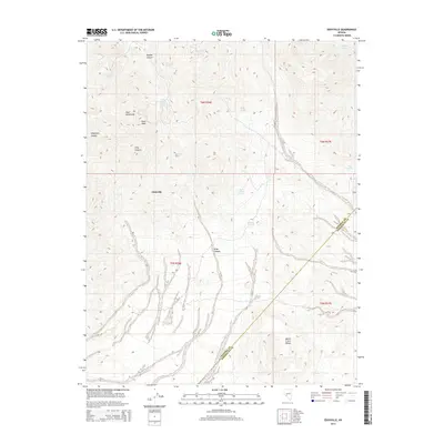
2014 Map of Eddyville
USGS Topo · Published 2014About this map
Eddyville sits at the heart of this high-desert landscape where the Pilot Mountains meet the northern edge of the Monte Cristo Range. The topography is defined by significant elevation changes, anchored by the prominent Pilot Peak and segmented by deep seasonal drainages such as Dunlap Canyon and Telephone Canyon. Water sources are critical identifiers in this arid environment, with numerous named points including Warlock Spring, Cornelius Spring, and Dunlap Tunnel Spring indicating the precious locations of life-sustaining groundwater. The diagonal boundary between Mineral and Esmeralda counties cuts through the southern portion of the map, illustrating the administrative divisions of this sparsely populated Great Basin region. Further north, Wide Canyon and Long Canyon carve through the terrain, while reliable water points like Mustang Spring and Summit Spring highlight the historical importance of localized springs for travelers and ranching operations in this isolated Nevada territory.
Find a feature on this map
23 named features on this map. Tap any name to fly to it.
Don’t see what you’re looking for? This feature index may not catch every label — zoom into the map to look around manually.
Map Details
Editions of this 2014 Eddyville Map
This is the sole edition of this map. No revisions or reprints were ever made.
Other maps of this area

1907 · Tonopah
USGS Topo · 1:250,000

1908 · Tonopah
USGS Topo · 1:250,000
1909 · Hawthorne
USGS Topo · 1:250,000
1911 · Hawthorne
USGS Topo · 1:250,000
1915 · Hawthorne
USGS Topo · 1:250,000

1948 · Walker Lake
USGS Topo · 1:250,000

1956 · Tonopah
USGS Topo · 1:250,000
1957 · Walker Lake
USGS Topo · 1:250,000

1959 · Tonopah
USGS Topo · 1:250,000
1962 · Walker Lake
USGS Topo · 1:250,000