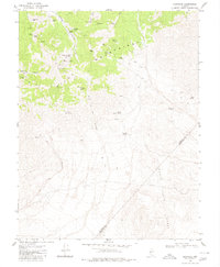
1980 Map of Eddyville
USGS Topo · Published 1980About this map
The Pilot Mountains dominate this high-desert landscape in central Nevada, where steep peaks and deep canyons are defined by a long history of mineral exploration. The terrain is pocketed with numerous mining operations including the Dunlap Mine, Warlock Mine, and Reward Mine, many of which are situated near critical water sources like Warlock Spring and Cornelius Spring. The small settlement of Eddyville sits at the transition between the uplands and the expansive Wide Canyon. To the south, the survey tracks the boundary between Mineral Co and Esmeralda Co, crossing into the northern reaches of the Monte Cristo Range. A network of primitive transport routes, marked by jeep trails, connects isolated sites such as the Sullivan Mine and Lost Steers Mine, illustrating the rugged logistics of the region's late-twentieth-century mining industry.
Find a feature on this map
38 named features on this map. Tap any name to fly to it.
Don’t see what you’re looking for? This feature index may not catch every label — zoom into the map to look around manually.
Map Details
Editions of this 1980 Eddyville Map
This is the sole edition of this map. No revisions or reprints were ever made.
Other maps of this area

1907 · Tonopah
USGS Topo · 1:250,000

1908 · Tonopah
USGS Topo · 1:250,000

1909 · Hawthorne
USGS Topo · 1:250,000

1911 · Hawthorne
USGS Topo · 1:250,000

1915 · Hawthorne
USGS Topo · 1:250,000

1948 · Walker Lake
USGS Topo · 1:250,000

1956 · Tonopah
USGS Topo · 1:250,000

1957 · Walker Lake
USGS Topo · 1:250,000

1959 · Tonopah
USGS Topo · 1:250,000

1962 · Walker Lake
USGS Topo · 1:250,000