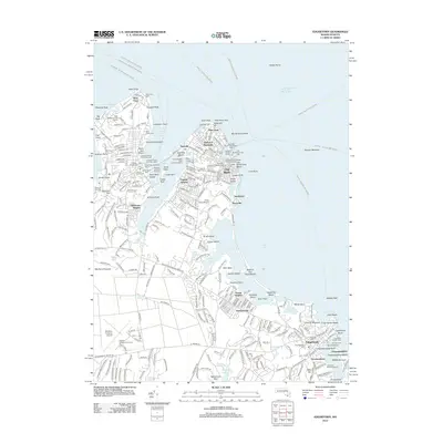
2012 Map of Edgartown
USGS Topo · Published 2012About this map
Edgartown and Oak Bluffs serve as the primary coastal hubs on this detailed 2012 survey of eastern Martha's Vineyard. The map documents the dense historic footprints of the Gingerbread Cottages and Tabernacle and the Marthas Vineyard Campground, alongside essential maritime infrastructure like the Steamship Authority Wharf and the OnTime Ferry crossing to Chappaquiddick. The island's nautical history is anchored by its lighthouse network, including West Chop Light, East Chop Light, and the Edgartown Harbor Light.
Find a feature on this map
296 named features on this map. Tap any name to fly to it.
Don’t see what you’re looking for? This feature index may not catch every label — zoom into the map to look around manually.
Map Details
Editions of this 2012 Edgartown Map
This is the sole edition of this map. No revisions or reprints were ever made.
Other maps of this area

1886 · Falmouth
USGS Topo · 1:62,500

1887 · Marthas Vineyard
USGS Topo · 1:62,500

1888 · Falmouth
USGS Topo · 1:62,500

1889 · Marthas Vineyard
USGS Topo · 1:62,500

1893 · Falmouth
USGS Topo · 1:62,500

1894 · Marthas Vineyard
USGS Topo · 1:62,500

1915 · Falmouth
USGS Topo · 1:62,500

1920 · Falmouth
USGS Topo · 1:62,500
1936 · Falmouth
USGS Topo · 1:25,000
1936 · Woods Hole
USGS Topo · 1:24,000