
1887 Map of Marthas Vineyard
USGS Topo · Published 1887About this map
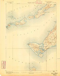
Marthas Vineyard is presented here in the late 19th century, featuring a detailed coastline defined by its numerous coastal ponds and historic harbor settlements. The topography, surveyed by E.B. Clark, highlights the transition of the island's eastern end, where Cottage City and Highlands stand near the busy waters of Nantucket Sound. Further south, the map details the intricate geography of Chappaquiddick Id. and the extensive series of southern great ponds, including Tisbury Great Pond and Edgartown Great Pond.
Find a feature on this map
70 named features on this map. Tap any name to fly to it.
Don’t see what you’re looking for? This feature index may not catch every label — zoom into the map to look around manually.
Map Details
Editions of this 1887 Marthas Vineyard Map
This is the sole edition of this map. No revisions or reprints were ever made.
Other maps of this area

1886 · Falmouth
USGS Topo · 1:62,500

1887 · Gay Head
USGS Topo · 1:62,500

1887 · Muskeget
USGS Topo · 1:62,500

1888 · Falmouth
USGS Topo · 1:62,500

1889 · Muskeget
USGS Topo · 1:62,500

1889 · Gay Head
USGS Topo · 1:62,500

1889 · Marthas Vineyard
USGS Topo · 1:62,500

1893 · Muskeget
USGS Topo · 1:62,500
1893 · Gay Head
USGS Topo · 1:62,500

1893 · Falmouth
USGS Topo · 1:62,500