
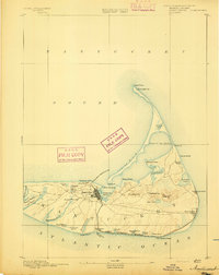
1889 Map of Muskeget
USGS Topo · Published 1889About this map
Muskeget Id. and Tuckernuck Id. sit at the western approach to Nantucket, captured here during the late nineteenth-century surveying efforts of Henry Gannett and Marcus Baker. This coastal survey delineates the intricate shoreline and tidal waterways between the Atlantic Ocean and Nantucket Sound just before the turn of the century. On the western tip of Nantucket Island, the map documents the complex creek systems surrounding Maddequet Harbor, including Further Cr., Narrow Cr., and Broad Cr.. These maritime features, along with North Pond and East Pond on Tuckernuck, provide a baseline for understanding the shifting sands and coastal geomorphology of these exposed islands. The work represents a collaboration between the U.S. Geological Survey and the State of Massachusetts Commissioners, reflecting the era's focus on precise maritime and topographical documentation.
Find a feature on this map
13 named features on this map. Tap any name to fly to it.
Don’t see what you’re looking for? This feature index may not catch every label — zoom into the map to look around manually.
Map Details
Editions of this 1889 Muskeget Map
This is the sole edition of this map. No revisions or reprints were ever made.
Other maps of this area

1887 · Muskeget
USGS Topo · 1:62,500

1887 · Marthas Vineyard
USGS Topo · 1:62,500

1887 · Yarmouth
USGS Topo · 1:62,500

1889 · Yarmouth
USGS Topo · 1:62,500

1889 · Marthas Vineyard
USGS Topo · 1:62,500

1889 · Nantucket
USGS Topo · 1:62,500
1893 · Nantucket
USGS Topo · 1:62,500

1893 · Muskeget
USGS Topo · 1:62,500
1893 · Yarmouth
USGS Topo · 1:62,500

1894 · Marthas Vineyard
USGS Topo · 1:62,500