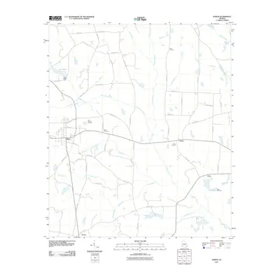
2011 Map of Edison
USGS Topo · Published 2011About this map
Edison serves as the primary hub of this Southwest Georgia landscape, where a dense network of county roads radiates through the agricultural terrain. The settlement of Dickey sits to the east, while Turman marks the southern reach near the confluence of local drainage basins. The area's history is deeply rooted in its small communities, evidenced by a high density of family and community burial grounds including Saint Stevens Cemetery, Salem Cemetery, and Regan Cemetery.
Find a feature on this map
61 named features on this map. Tap any name to fly to it.
Don’t see what you’re looking for? This feature index may not catch every label — zoom into the map to look around manually.
Map Details
Editions of this 2011 Edison Map
This is the sole edition of this map. No revisions or reprints were ever made.
Other maps of this area

1953 · Dothan
USGS Topo · 1:250,000

1954 · Dothan
USGS Topo · 1:250,000

1955 · Dothan
USGS Topo · 1:250,000

1973 · Morgan
USGS Topo · 1:24,000

1973 · Martins Crossroads
USGS Topo · 1:24,000

1973 · Bancroft
USGS Topo · 1:24,000
1973 · Doverel
USGS Topo · 1:24,000

1973 · Edison
USGS Topo · 1:24,000
1973 · Carnegie
USGS Topo · 1:24,000
1973 · Bluffton
USGS Topo · 1:24,000