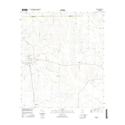
2014 Map of Edison
USGS Topo · Published 2014About this map
Edison serves as the primary hub of this Southwest Georgia landscape, where agricultural roads branch out from the intersection of Ga-37 and Ga-216. The terrain is defined by a dense network of tributaries including Little Pachitla Cr and Neals Creek, which feed into the larger Pachitla Creek system. The area's social history is recorded in its rural cemeteries, such as Saint Stevens Cem near the town center and Salem Cem further east, alongside small settlements like Dickey and Turman. The presence of Merrett Pond and Taylor Lake among the many winding branches like Bay Branch and Hood Br illustrates a landscape shaped by significant drainage patterns typical of the region. This 2014 edition captures the modern road network while preserving the locations of family burial grounds and established local landmarks.
Find a feature on this map
85 named features on this map. Tap any name to fly to it.
Don’t see what you’re looking for? This feature index may not catch every label — zoom into the map to look around manually.
Map Details
Editions of this 2014 Edison Map
This is the sole edition of this map. No revisions or reprints were ever made.
Other maps of this area

1953 · Dothan
USGS Topo · 1:250,000

1954 · Dothan
USGS Topo · 1:250,000

1955 · Dothan
USGS Topo · 1:250,000

1973 · Morgan
USGS Topo · 1:24,000

1973 · Martins Crossroads
USGS Topo · 1:24,000

1973 · Bancroft
USGS Topo · 1:24,000
1973 · Doverel
USGS Topo · 1:24,000

1973 · Edison
USGS Topo · 1:24,000
1973 · Carnegie
USGS Topo · 1:24,000
1973 · Bluffton
USGS Topo · 1:24,000