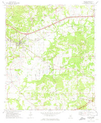
1972 Map of Edwards
USGS Topo · Published 1974About this map
The town of Edwards sits at the western edge of this 1972 survey, centered on a landscape defined by its deep historical and religious footprint. The topography is dominated by the ridges of Champion Hill, a location of immense significance for those tracing regional civil war history or family genealogy. The Illinois Central railroad cuts through the center of the sheet, reflecting the area's continued reliance on rail infrastructure for the transport of local goods, while the Natchez Trace Parkway skirts the southern border, marking the modern evolution of an ancient travel corridor.
Find a feature on this map
39 named features on this map. Tap any name to fly to it.
Don’t see what you’re looking for? This feature index may not catch every label — zoom into the map to look around manually.
Map Details
Editions of this 1972 Edwards Map
3 editions found
Other maps of this area

1903 · Jackson
USGS Topo · 1:125,000

1934 · Raymond
USGS Topo · 1:48,000

1937 · Raymond
USGS Topo · 1:62,500

1937 · Terry
USGS Topo · 1:48,000

1938 · Edwards
USGS Topo · 1:62,500

1942 · Raymond
USGS Topo · 1:62,500

1943 · Terry
USGS Topo · 1:62,500

1955 · Jackson
USGS Topo · 1:250,000

1961 · Jackson
USGS Topo · 1:250,000

1962 · Jackson
USGS Topo · 1:250,000